Northeast 2014
July 2014
We left home July 10, 2014, for a two-week driving tour of the Northeast. It was a chance to hike in Virginia, Maine, and New Hampshire; to visit family in Virginia and Rhode Island; and to see Niagara Falls, which was on Mary’s bucket list. It was also an opportunity for Keith to see seven states that he had never visited before (bringing his total to 45).
Grayson Highlands State Park, Virginia
Our first stop was at a bed-and-breakfast called the Duck Roost Inn in Mouth of Wilson, Virginia. It was a clean, comfortable, old-fashioned house in a quiet, out-of-the-way location, and our hosts Kate and Mark treated us like family. Kate is also an excellent cook. We enjoyed our stay there and would definitely go back.
The next day we hiked at Grayson Highlands State Park.
) Wild but very tame ponies along the trail
Wild but very tame ponies along the trail) This foal tried to nibble Mary’s pants, forcing her to brush his head away gently and repeatedly with her hand (but we wouldn’t say
This foal tried to nibble Mary’s pants, forcing her to brush his head away gently and repeatedly with her hand (but we wouldn’t say petting,which is frowned upon).
) Information about the wild ponies
Information about the wild ponies) Keith on the Wilburn Ridge Trail
Keith on the Wilburn Ridge Trail) Keith hiking near longhorns on the Wilburn Ridge Trail
Keith hiking near longhorns on the Wilburn Ridge Trail) Longhorns
Longhorns) A tight spot called
A tight spot called Fat Man’s Squeeze
) Crossing one of the fences that help to control the ponies
— Notice the rhododendrons in bloom.
Crossing one of the fences that help to control the ponies
— Notice the rhododendrons in bloom.) Wise shelter on the AT
Wise shelter on the AT) At the top of the
At the top of the Appalachian Spur Trail,Mary climbed some rocks to get a better view and took this shot with Keith waiting below.
After leaving Mouth of Wilson the next day, we drove to Alexandria, Virginia, for a one-night visit with Mary’s brother Bill and sister-in-law Mary.
West Point, New York
After the visit in Alexandria, we drove by way of Maryland, Delaware and New Jersey to the US Military Academy at West Point, New York, where we spent one night at the Thayer Hotel. Mary showed Keith around the grounds of West Point and we took a short walk up a trail that turned out to be Flirtation Walk, which is marked (at the other end) as off-limits to anyone not accompanied by a cadet. We would have seen more, but many areas are now off-limits to visitors since someone a couple of years ago walked around the grounds taking photographs that he later published in an unflattering story about the place.
) Hudson River
Hudson River) Barracks and chapel
Barracks and chapel) Statue of Washington
Statue of WashingtonRhode Island (and Providence Plantations)
When we left West Point, we drove through Connecticut to Wakefield, Rhode Island, for a two-night visit with Mary’s cousin Joanne. Joanne showed us around Narragansett and Newport, and we toured The Breakers, one of the Newport mansions, built by Cornelius Vanderbilt, II.
) Rock art at the Narragansett shore
Rock art at the Narragansett shore) More rock art
More rock art) And more
And more) Imagine what happens if one of these rocks falls while you’re standing next to it.
Imagine what happens if one of these rocks falls while you’re standing next to it.) Joanne took us to see the Beavertail Lighthouse.
Joanne took us to see the Beavertail Lighthouse.) The lighthouse and museum
The lighthouse and museum) Foundation of the old lighthouse
Foundation of the old lighthouse ) Close-up of the plaque on the foundation
Close-up of the plaque on the foundation) A little history
A little history) Mary and Joanne at Fort Adams State Park, Newport, RI
Mary and Joanne at Fort Adams State Park, Newport, RI) Mary and Joanne at The Breakers, Newport, RI
Mary and Joanne at The Breakers, Newport, RI) Outside The Breakers — No photos are allowed inside.
Outside The Breakers — No photos are allowed inside.Connecticut
After Rhode Island we went back into Connecticut for a brief visit and dinner with our old friend Doug Van Cleef, who was working that week in Meriden. On the way to see Doug, we stopped first in Mystic, Connecticut, and then in East Haddam for a tour of Gillette Castle. We had hoped to see the schooner Mystic, which Mary’s son Jason had crewed in 2013, but we didn’t find it, and the locals told us it had been sold.
) On the Mystic River
On the Mystic River) The town of Mystic
The town of Mystic) Mystic
Mystic) Drawbridge over the Mystic River
Drawbridge over the Mystic River) Gillette Castle
Gillette Castle) Gillette Castle
Gillette Castle) Stone arch
Stone arch) Stairs just inside the castle entrance
Stairs just inside the castle entrance) Carved wooden switches
Carved wooden switches) Living room
Living room) Porch with a view
Porch with a view) Upstairs hallway
Upstairs hallway) After touring the castle, we took the Chester-Hadlyme Ferry across the river to save a few minutes.
After touring the castle, we took the Chester-Hadlyme Ferry across the river to save a few minutes.) Waiting to board
Waiting to board) Leaving the dock
Leaving the dock) On the ferry. It seemed a little strange to open the door and step out of the
vehicle while it was moving.
On the ferry. It seemed a little strange to open the door and step out of the
vehicle while it was moving.After Connecticut we headed to Bar Harbor, Maine.
Acadia National Park, Maine
We checked into the Castlemaine Inn in Bar Harbor for two nights, and we were very pleased with our hosts and the accomodations. (We took the Eyebrow Suite on the third floor.) Dan advised us about hiking trails in Acadia National Park. We took his advice and had a full and enjoyable day of hiking and sightseeing.
) The Castlemaine Inn
The Castlemaine Inn) Soon after checking in, Mary relaxed for a few minutes and phoned home from our third-floor balcony at the Castlemaine Inn.
Soon after checking in, Mary relaxed for a few minutes and phoned home from our third-floor balcony at the Castlemaine Inn.In the morning we drove around Park Loop Road to the trailhead for Gorham Mountain. Our plan was to take the trail over Gorham Mountain, continue north and take a detour over Beehive, and then hike over and beyond Champlain Mountain. We would reach Park Loop Road again several miles to the north and catch a park shuttle back to the car at the original trailhead. We would have considered the Precipice Trail but it was closed because of nesting peregrine falcons.
) View from the Gorham Mountain Trail looking toward Otter Point
View from the Gorham Mountain Trail looking toward Otter Point) At the top of Gorham Mountain
At the top of Gorham Mountain) When we saw the Beehive, we were pretty sure we would climb it.
When we saw the Beehive, we were pretty sure we would climb it.) View of the Beehive from the trail below
View of the Beehive from the trail below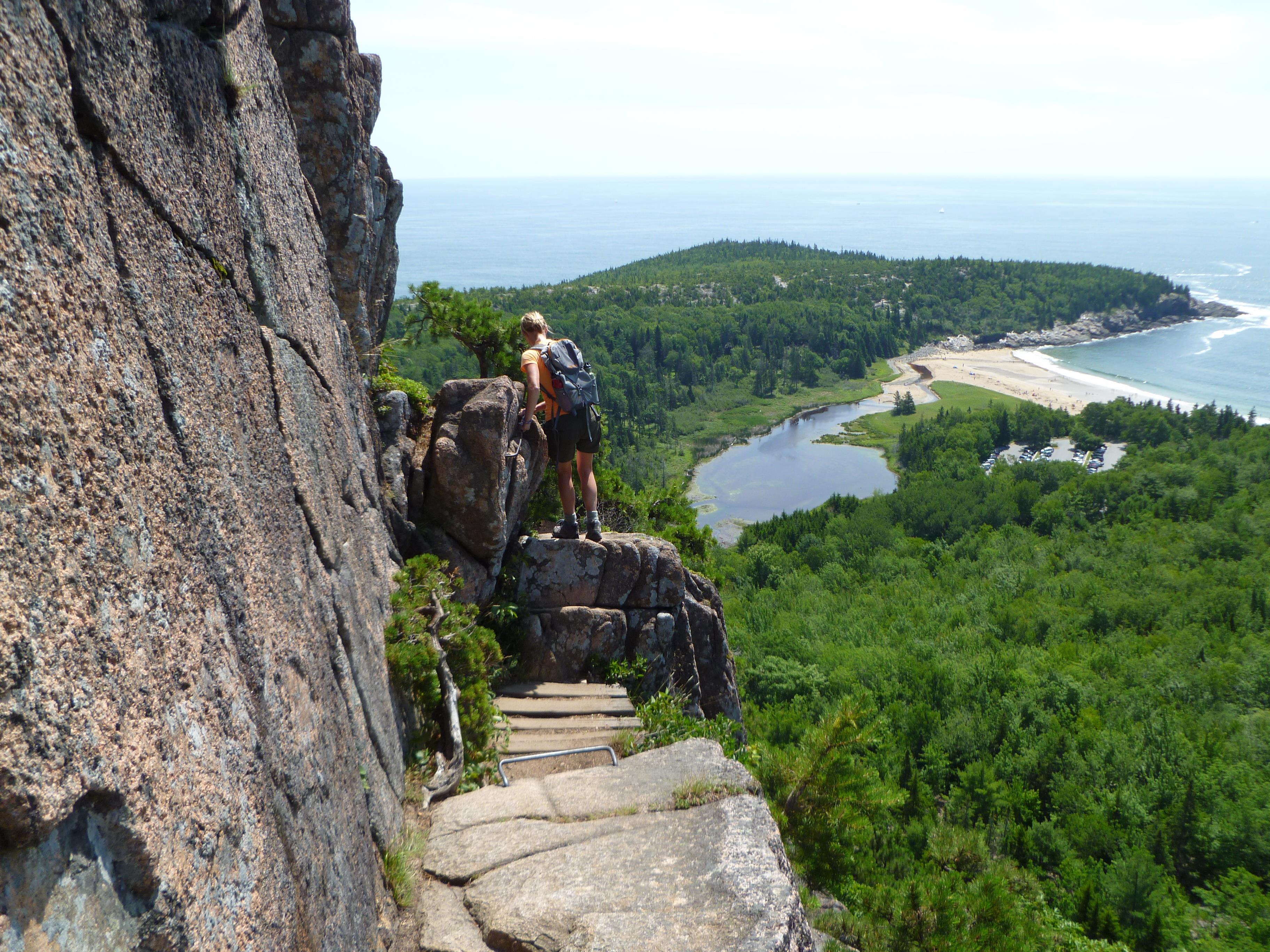
) Keith turned a corner, saw this view and said,
Keith turned a corner, saw this view and said, Cool!The woman ahead of him turned and said,
Not the word I would have chosen.
) Mary got a shot of Keith proceeding cautiously,
or maybe he was still putting his camera away on his belt.
Mary got a shot of Keith proceeding cautiously,
or maybe he was still putting his camera away on his belt.) Keith looked back and found Mary in a perfect spot for a photograph that would capture the experience.
Keith looked back and found Mary in a perfect spot for a photograph that would capture the experience.) Mary reaches the summit of the Beehive.
Mary reaches the summit of the Beehive.) Keith cools off in the breeze after climbing the Beehive. The Bowl is visible below.
Keith cools off in the breeze after climbing the Beehive. The Bowl is visible below.) The Bowl comes into view.
The Bowl comes into view.) At the top of Champlain Mountain
At the top of Champlain Mountain) Other hikers enjoy the view from Champlain Mountain.
Other hikers enjoy the view from Champlain Mountain.) View from Champlain Mountain in the direction of Bar Harbor
View from Champlain Mountain in the direction of Bar Harbor) After the hikes we did a little sightseeing on the way back. This is a view of Jordan Pond.
After the hikes we did a little sightseeing on the way back. This is a view of Jordan Pond.) Finally, at the end of a long day, we drove to the top of Cadillac Mountain.
Finally, at the end of a long day, we drove to the top of Cadillac Mountain.Franconia Notch, New Hampshire
After Acadia we drove across Maine and into New Hampshire. We stayed at the Franconia Notch Guest House, a hiker-friendly bed-and-breakfast, and again we were very pleased with our hosts and the accomodations. Tom and Pauline really treated us like family.
We went to New Hampshire to hike along the Franconia Ridge in the White Mountains. We were advised to go up the Falling Waters Trail, across the ridge, and then down the Greenleaf Trail and Old Bridle Path Trail to close the loop. The Falling Waters Trail is steep and rocky, and the rocks in some places are wet. We think the advice was good. It’s hard enough to go up a steep, wet, rocky trail, but going down would have been much worse.
) They were expecting us at the FNGH.
They were expecting us at the FNGH.) The great room
The great room) Signpost near the trailhead (photo taken at the end of the hike after the sun had come out)
Signpost near the trailhead (photo taken at the end of the hike after the sun had come out)) Beginning of the Falling Waters Trail
Beginning of the Falling Waters Trail) Stream crossing at the start of the Falling Waters Trail
Stream crossing at the start of the Falling Waters Trail) Falling waters
Falling waters) Falling waters
Falling waters) Mary crosses the stream.
Mary crosses the stream.) Falling waters—There are several pretty waterfalls along
the way, which means the stream has a steep grade, which means the Falling Waters Trail beside it also has a steep grade.
Falling waters—There are several pretty waterfalls along
the way, which means the stream has a steep grade, which means the Falling Waters Trail beside it also has a steep grade.) Falling waters
Falling waters
) One of many stream crossings
One of many stream crossings) In some places the trail is very steep and rough.
In some places the trail is very steep and rough.) Yes, that’s a trail; Keith is hiking it.
Yes, that’s a trail; Keith is hiking it.) Mary reaches the top of Little Haystack. Zoom in for
a different perspective.
Mary reaches the top of Little Haystack. Zoom in for
a different perspective.) It was breezy and very cool at the top, but Keith
enjoyed it in short sleeves for a few minutes while
shedding some of the heat generated by the previous three miles of steep climbing.
It was breezy and very cool at the top, but Keith
enjoyed it in short sleeves for a few minutes while
shedding some of the heat generated by the previous three miles of steep climbing.) On the ridge trail to Mt. Lincoln
On the ridge trail to Mt. Lincoln) The trail to Mount Lafayette
The trail to Mount Lafayette) At the summit of Mount Lafayette
At the summit of Mount Lafayette) At the summit of Mount Lafayette
At the summit of Mount Lafayette) The Greenleaf Trail — Greenleaf Hut is visible below.
The Greenleaf Trail — Greenleaf Hut is visible below.) Mary on the Greenleaf Trail
Mary on the Greenleaf Trail) The Greenleaf Hut
The Greenleaf Hut) We spoke briefly with this friendly employee at the Greenleaf Hut.
Keith had to tell him the radiation warning sign ☢ didn’t scare him.
We spoke briefly with this friendly employee at the Greenleaf Hut.
Keith had to tell him the radiation warning sign ☢ didn’t scare him.) View from the Old Bridle Path Trail
View from the Old Bridle Path Trail) View from the Old Bridle Path Trail
View from the Old Bridle Path Trail) View of Franconia Ridge from the Old Bridle Path Trail
View of Franconia Ridge from the Old Bridle Path Trail) Zoomed view of Shining Rock, with increased color saturation to compensate for
the effects of distance.
Zoomed view of Shining Rock, with increased color saturation to compensate for
the effects of distance.) Shortly after hitting the road, we saw a line of
cars stopped by the highway. We stopped too, expecting—correctly—to see
a moose. The moose ignored the crowd until one woman (not Mary) got too close. Luckily for her the moose chose to walk away.
Shortly after hitting the road, we saw a line of
cars stopped by the highway. We stopped too, expecting—correctly—to see
a moose. The moose ignored the crowd until one woman (not Mary) got too close. Luckily for her the moose chose to walk away.) Mary got a better photo.
Mary got a better photo.) Back at the Guest House: a view of the notch in the light of the setting sun
Back at the Guest House: a view of the notch in the light of the setting sun) Our last morning at the Guest House, while we were eating breakfast, Pauline told us there was a bear in the field
behind the inn. We left breakfast and watched the bear lying under an apple tree. After a while another bear showed up,
chased the first bear away, and claimed the apple tree for itself.
Our last morning at the Guest House, while we were eating breakfast, Pauline told us there was a bear in the field
behind the inn. We left breakfast and watched the bear lying under an apple tree. After a while another bear showed up,
chased the first bear away, and claimed the apple tree for itself.Mary came across a good description of this hike after we returned home.
Niagara Falls, New York
From New Hampshire we drove down and across Vermont and then across New York on the thruway to Buffalo and up to Niagara Falls. After being spoiled by Tom and Pauline at Franconia Notch, we had lower expectations for Niagara Falls, but our experience there was also mostly good. We met mostly friendly people, with the exception of two border guards and one young Canadian hot dog vendor. The Canadian border guard was businesslike and maybe a little perfunctory, but the American border guard seemed downright unfriendly. When we left, Mary thanked him for his work and got no acknowledgment. The hot dog vendor clearly did not enjoy selling hot dogs in the summer heat (upper 80s Fahrenheit, more than 30 °C).
) We arrived early enough to see the falls before sunset.
We arrived early enough to see the falls before sunset.) View from Prospect Point in the late sunlight —
Maybe our prettiest shot of the falls
View from Prospect Point in the late sunlight —
Maybe our prettiest shot of the falls) View from the pedestrian bridge to Goat Island.
The rapids would be impressive even without the waterfall.
View from the pedestrian bridge to Goat Island.
The rapids would be impressive even without the waterfall.) The next morning we took one of the early Maid of the Mist tours and beat the crowds. Later in the day this boat would be packed.
The next morning we took one of the early Maid of the Mist tours and beat the crowds. Later in the day this boat would be packed.) American Falls with Horseshoe Falls in the distance
American Falls with Horseshoe Falls in the distance) At the bottom of American Falls during the Cave of the Winds tour
At the bottom of American Falls during the Cave of the Winds tour) Looking north (more or less) from Luna Island
Looking north (more or less) from Luna Island) We also brought our passports to see the
Canadian side, which has the most popular views. This photo shows the best view from the Rainbow Bridge.
We also brought our passports to see the
Canadian side, which has the most popular views. This photo shows the best view from the Rainbow Bridge.) First view from Canadian soil
First view from Canadian soil) There’s a hole in the river.
There’s a hole in the river.) While in Canada we took the
While in Canada we took the Journey Behind the Falls.The view from the portals is really not impressive, especially after such a long wait to see it.
) Portal 2: Journey Behind the Falls
Portal 2: Journey Behind the Falls) The view from the observation deck was better. (We have no explanation for the feet in the air.)
The view from the observation deck was better. (We have no explanation for the feet in the air.)) The (Canadian) Hornblower tour boat approaches Horseshoe Falls
The (Canadian) Hornblower tour boat approaches Horseshoe Falls) Horseshoe Falls
Horseshoe Falls) Rainbow in front of the American Falls
Rainbow in front of the American Falls) As we walked back to the US, we were happy to be on foot, but we still had a 20 to 30-minute wait at the end,
where we got the evil eye from US Customs and Border Protection.
As we walked back to the US, we were happy to be on foot, but we still had a 20 to 30-minute wait at the end,
where we got the evil eye from US Customs and Border Protection.